
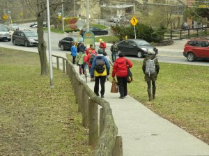
Are you interested in water quality and the environment in Toronto? Then you would have been interested in a 2014 Jane’s Walk called “A Raindrop’s Journey in Rosedale Valley“.
The walk traced a how a raindrop travels along Rosedale Valley Road to the Don River and taught walkers about the valley’s history while learning about water quality and conservation.
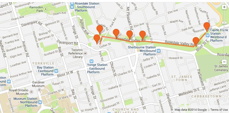
The Walk’s Stops

A list of stops along the walk where the environment’s water and local history was discussed along with notes for the walk. Landmarks are pointed out along the walk and details on these interesting places are found in the references section after this article mainly from Riversides and the Toronto Star.
1. Asquith Green Park – meeting site
A wide open park with a concrete stage to stand up on to easily talk to the walk group as they gather.
2. Park Road West side at Church
Cross the road carefully to reach the sidewalk and descend into the valley on Park Road slowly as the path can be steep or slippery when wet.
3. Lawren Harris Park
Look at sign at the west end of the park at the bottom of the valley. The sign is close to Rosedale Valley Road.

A good spot to talk about:
- the rich hunting/fishing area (First Nations usage of the area)
- recent history of the region (1800 – present)
- how people used the river for fun activities in the past
- a link to Jane Jacob’s work along Castle Frank Brook at Cedarvale Park.
- Group of 7 studio is visible to the west
- brewery used to be in the area
- ravine history
4. Hazeldean Park
- See the Hazeldean sign and painting. Note Rosedale Villa was on east side of ravine
- Bell box mural is seen across the street reflecting the neighbourhood (combination of nature and residential)
- Eulogy to Beauty plaque in Hazeldean park.
5. Observe the Bluebells (invasive species)

Bluebells are growing along slope in valley and are visible in spring, summer and fall. There are gardens growing on the top of the valley from houses.
6. Glacial Rocks (Parking Entrance)
Walking west along the path, we reached a parking entrance with glacial rocks in front showing the area’s geological history.
7. Small Hill Between Mt. Pleasant and Sherbourne Bridges

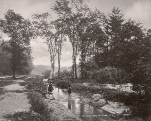
There was a brewery here on the on south side of valley where the hill is. Observe the garbage than came from run off in the area. The brewery dammed the river in the past creating a lake for water sports throughout the year.
8. Storm Sewers
Along path, see how many storm sewers you can spot.
9. Subway Tunnel

Approaching the Parliament bridge, look at subway tunnel overhead which is a completely covered bridge for noise reduction.
Note the large amount of soil run off near the foot of the bridge.
10. Don Valley lookout point / campsite

Under the Parliament bridge, take a path to the right that climbs up towards St. James Cemetary. Along the path, you’ll see some fallen logs and an area that looks like a campsite.
The campsite shows the multiple uses of area of the ravine for sport, living, and recreational activities. Under the bridge, you’ll find evidence of people temporarily using the bridge as a shelter/living area sometimes. The campsite is a near the connection on Parliament for the mid-Toronto interceptor sewer. A discussion on where water goes in a storm and why disconnecting downspout is important.
11. Bloor-ParliamentParkette
Climb up the ravine path to end up near Parliament and Bloor at the parkette. The path is rough, though well traveled and should be visible by the many rocks on the path. Head across the bridge towards the Don Valley offering a good view of Rosedale Valley from above.
12. Castle Frank Marker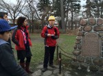
The approximate location of the original Castle Frank house has a red stone market by the Don Valley (now Toronto Regional) Conservation Authority. Place to talk about recent history of Castle Frank and how the region got its name.
13. Castle Frank TTC Station
The End of Walk!
About the Walk
Creating the Walk
So how was this walk created? With help from people, the library, and internet resources 🙂
In particular, generous library and online resources from people who genuinely care about the water quality and health of our environment in the city. The Jane’s Walk Toronto Walkshops held prior to the walks in 2014 gave me access to volunteers and staff who identified themes walkers would be interested in and gave advice on how to hold a safe, fun, and engaging walk.
After that, it was:
- Doing lots of reading like the articles below. The areas I researched were:
- water quality
- invasive species and plant life
- Toronto’s ravine and sewer system and their relationships
- Toronto’s rivers and their history
- Gathering photos and remember my past experience in the walk area, especially on day hikes.
- Mapping out a walk and planning for possible things like weather, large groups, “plan B paths”.
- Walking the path and looking for points of interest as a test run.
About the Walk Leader Justin

I’ve lived in the downtown area for more than 30 years and went to school/played with friends as a child in the Rosedale area.
In a quest to learn about the city and its history, I’ve extensively explored the downtown area by bike, foot, and online too! I’m a civil servant and passionate about sharing our environment and a healthy city.
References
Battersby, Helen. “Rosedale Valley Road’s bluebell glade”. Toronto Gardens. 16 April 2009. Web. 17 April 2014.
Brown, Alan L. “Eulogy to Beauty Historical Plaque”. Toronto Historical Plaques. n.d. Web. 2 May 2014.
“Box Art and Bright Green Balloons”. Walking Woman. 3 April 2013. Web. 17 April 2014.
“City of Toronto and Bell Canada step outside the box with one-of-a-kind urban art on the box”. City of Toronto. 14 June 2006. Web. 17 April 2014.
“Controlling Invasive Plants”. City of Toronto. 2013. Web. 15 April 2014.
Hare, Peter, Toronto Green Community and Toronto Field Naturalists. “Castle Frank Brook”. Lost River Walks. n.d. Web. 14 April 2014.
Limeback, Rudy. “Six ravines and an abandoned rail line”. Rudy.ca. 21 April 2012. Web. 14 April 2014.
Powers, Lucas. “Urban flooding likely to worsen”. CBC. 11 July 2014. Web. 14 April 2014.
Mayers, Adam. “The Real Castle Frank”. Toronto Star. 8 March 2007. Web. 14 April 2014.
RiverSides: Where Water Quality Begins. RiverSides, 2009. Web. 13 April 2014.
“Rosedale Ravine Trail”. Ontario Trails Council. n.d. Web. 14 April 2014.
“Rosedale Valley Road”. Toronto Public Library. n.d. Web. 14 April 2014.
Ontario Streams. Ontario Streams, 2014. Web. 22 March 2014.
“The Water in the City Walk: Self-guided Tour”. RiverSides. 2007 Web. 13 April 2014.
The Vanishing Point: water underground. Vanishing Point. 2013. Web. 12 April 2014.
